
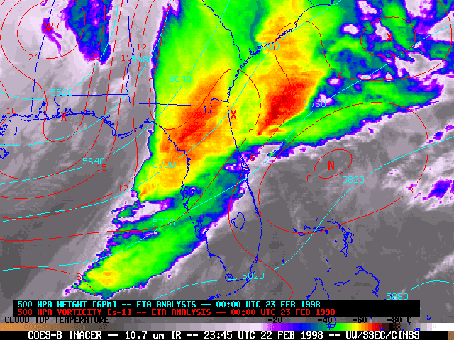

WBWX – In the dark, pitch-black hours of night, between 11 p.m. and 2:30 a.m. on Sunday, February 22nd and Monday the 23rd of 1998, seven tornadoes would tear across east-central Florida.
By sunrise on that Monday morning, more than 3,000 structures had been damaged and over 700 would be destroyed across 5 central Florida counties.
The human toll would cement the outbreak as Florida’s deadliest on record: 42 people were killed that night, while more than 260 were injured.
The 1998 Kissimmee Tornado Outbreak, or the “Night of the Tornadoes,” still holds this record to this day, being doubled that of the second deadliest record of 17 tornado related deaths set in March of 1962.
Now, nearly three decades later, Florida is heading into another winter expected to be dominated by a very strong El Niño.
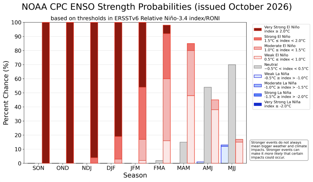
On October 8th, NOAA’s Climate Prediction Center (CPC) put the chance of a very strong event this fall at 100%, and many meteorologists have compared this El Niño’s onset and strength to the one that shaped the winter of 1997–98.
With another historically strong El Niño taking shape in the Pacific in 2026, we’ll look back at the night of February 22–23, 1998, and explore what that historic outbreak can tell us about the months ahead.
An Outbreak Forecasters Saw Coming
Forecasters in 1997 didn’t need anyone to tell them that El Niño and an increase in severe weather outbreaks in Florida were connected.
By this point in time, research completed by Bart Hagemeyer, the former Meteorologist-In-Charge (MIC) at NWS Melbourne, had indeed found that strong El Niño events increased the odds for the ingredients responsible for tornadoes to coalesce over Florida.
It was with this understanding that NWS Melbourne began educating the public about this risk as early as October 1997.
On December 15th of that same year, Hagemeyer would even brief emergency managers from across Florida at a state-sponsored El Niño Summit about the dangers associated with this weather pattern.
Fast forwarding to February of 1998, we can see that the then record warm El Niño had indeed delivered damaging storms to Florida on February 2nd and Valentine’s Day. So, when NWS forecasters began to flag another system on Friday, February 20th, for the potential of severe weather, it looked like more of the same was on the way for the Sunshine State.
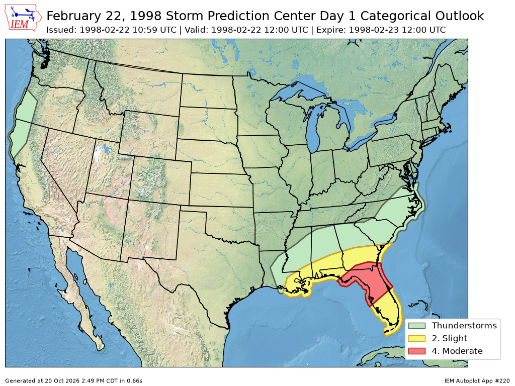
By the early morning of Sunday, February 22nd, 1998, the SPC had acknowledged the risk taking shape over central Florida, and upgraded their Severe Weather Outlook to a Moderate Risk (Level 2 of 3) for severe weather.
That evening, as NOAA’s service assessment put it, the atmosphere over east-central Florida would’ve been “primed for a devastating severe weather outbreak.”
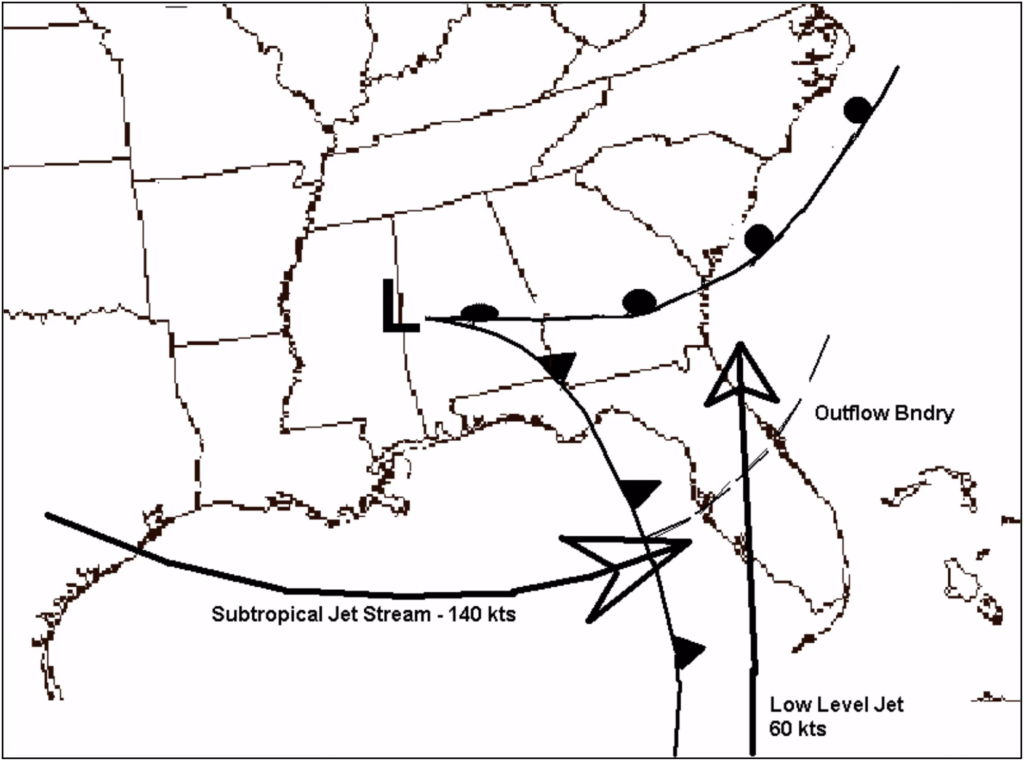
Aloft, a stronger-than-normal subtropical jet carried winds at around 140 knots (160mph) eastward across the peninsula, while near the ground, afternoon storms had left behind a remnant outflow boundary.
This leading edge of rain-cooled air stretched across the I-4 corridor from northeast of Tampa all the way across the peninsula to Daytona Beach, with warm, moist, and very unstable air to its south.
Shortly after sunset that evening, a strong low-level jet developed, blowing at more than 50 knots (60 mph).
Together, these two jets produced extreme wind shear, the change in wind speed or direction with height that allows a thunderstorm’s updraft to rotate.
As the storm system’s cold front swept across the eastern Gulf towards the Florida Peninsula, a line of storms would form and push ashore over the Tampa Bay area, running directly into the outflow boundary left from the storms earlier in the day.
This allowed three supercells to form that begin marching east towards Orlando.
It was then, over the following hours, that these storms would carve paths of destruction across six central Florida counties, long after most people had gone to bed for the evening.
‘The Night of the Tornadoes’
The northern supercell would be the first to produce a tornado, dropping an F2 in Volusia County, just southwest of Daytona Beach around 10:55 p.m.
This tornado would kill a man in a mobile home and overturn four tractor-trailers at the I-95/4 interchange, before moving offshore and over the Atlantic.
The middle supercell, however, would become cyclic, producing three tornadoes in succession.
The first, an F3, tore through the populated inner Orlando suburbs of Winter Garden and Ocoee in Orange County, between 11:47 p.m. and 11:55 p.m., killing three people and injuring 70.
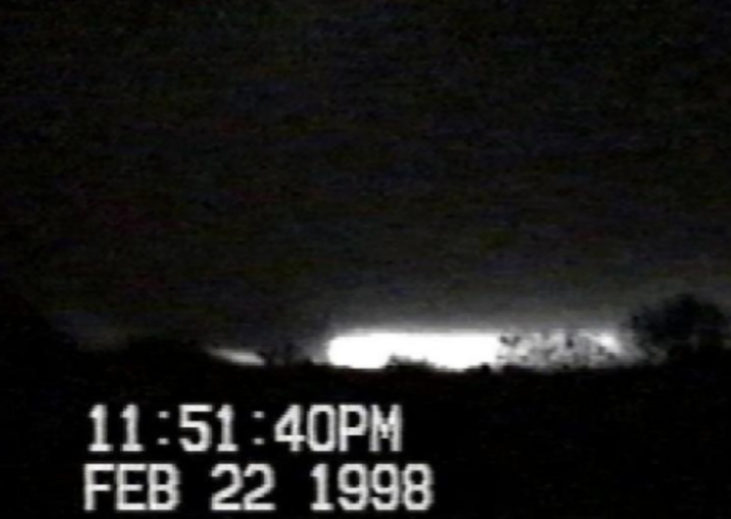
Ten minutes later, the same storm produced another F3 tornado, this time near Longwood in Seminole County.
It would quickly move into Sanford, cutting through neighborhoods and mobile home parks in the southeastern sections of the city, killing 12 people. It then claimed one more life at a fish camp along the St. Johns River.
Then, after midnight on Monday morning, at 12:40 a.m., the southern supercell would produce the deadliest tornado of the night.
This tornado touched down at 12:40 a.m., southwest of Kissimmee, just miles from Walt Disney World.
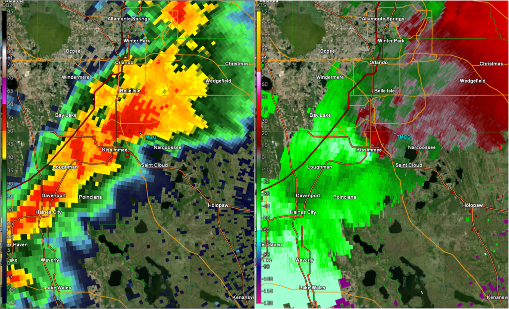
This F3 tornado tore through Kissimmee, damaging many subdivisions and, unfortunately, levelling several mobile home and RV parks.
Most of this tornado’s victims would be at the Ponderosa RV Park along Fortune Road, and the nearby Morningside Acres mobile home community, where the NWS’ service assessment team documented a narrow corridor of nearly total destruction.
Over a 38-mile path, the longest of the outbreak, the Kissimmee tornado killed 25 people, injured more than 150, and damaged or destroyed more than 1,000 structures.
That single tornado killed more people than any previous tornado outbreak in Florida.
The tornado was initially rated an F4, before then being downgraded to a high-end F3, with winds estimated at 200 miles per hour.
The NWS storm surveys can be found here:
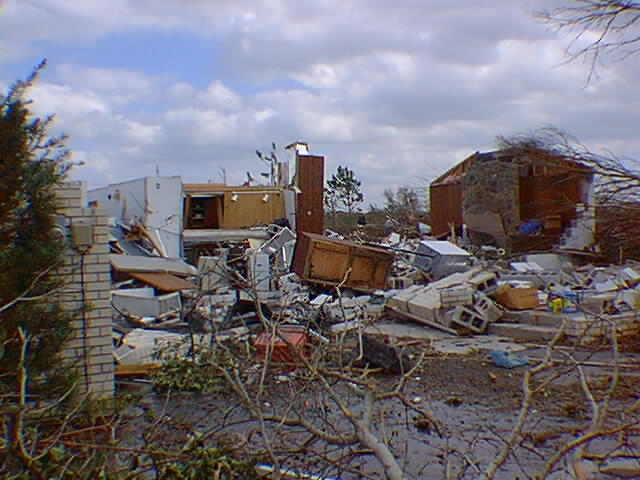
NWS Melbourne, FL
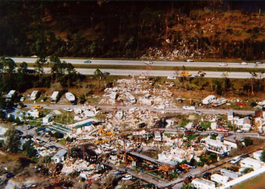
NWS Melbourne, FL
Additional smaller tornadoes followed near Oak Hill in Volusia County, and Titusville and Port Canaveral in Brevard County. In all, by the time the final storm slid out into the darkness over the Atlantic Ocean, the three supercells had produced seven tornadoes.
Damage topped $100 million, and 42 people had lost their lives, 40 of whom were in RVs, mobile homes, or manufactured housing.
So, what does the 1998 outbreak teach us?
The 1998 outbreak leaves many Floridians with two questions.
First, was the outbreak a direct result of the 1997–98 El Niño?
And secondly, with another powerful El Niño building in the Pacific this fall, could something like it happen again this winter?
The short answer to the first question is no, at least, not directly.
The 1997-98 El Niño didn’t create the storms that struck central Florida that night. However, it likely helped set the stage for them.
Learn more about the 2026 Super El Niño here:
El Niño is the periodic warming of the tropical Pacific Ocean, and it shifts weather patterns around the world.
During a strong El Niño, the winter jet stream over the U.S. often runs farther south, steering more storm systems across the Gulf into Florida and neighboring southern states.
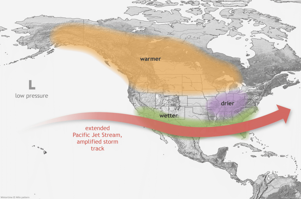
More storm systems mean more opportunities for the ingredients behind severe weather to come together, which in the decades since 1998, research has supported that Florida connection.
A 2008 study by Cook and Schaefer in Monthly Weather Review found that winter tornado outbreaks were less frequent nationally during El Niño than during neutral winters. Read that study here:
But the outbreaks that did occur favored the Gulf Coast states, including central Florida.
A 2018 study by Molina and colleagues in the Journal of Applied Meteorology and Climatology found that environments capable of producing significant tornadoes were more likely across the southern U.S. during El Niño. Read that study here:
Elsewhere in the country, the signal can run the other way.
A 2015 study by Allen, Tippett and Sobel in Nature Geoscience found that El Niño tends to bring fewer tornadoes to the central U.S. Read that study here:
So, in other words, El Niño doesn’t mean more tornadoes everywhere; it shifts where the risk tends to concentrate, and Florida sits squarely in that zone.
It is important to note that this connection comes with important caveats.
The same 2018 study by Molina and colleagues found large swings from one winter to the next, even during very strong events.
The SPC’s climatology notes that ENSO explains only a modest share of the year-to-year variation in U.S. cool-season tornado counts.
NWS Melbourne’s research centered on Florida points out that, even in El Niño winters, strong to violent tornadoes in Florida are rare, requiring several ingredients to come together.
So, El Niño loaded the dice in the winter of 1998, but it didn’t roll them.
What turned the 1998 Kissimmee Tornado Outbreak into a disaster was a specific set of ingredients lining up over central Florida on a single night, and no seasonal pattern can guarantee that.
That brings us to the second question: could something similar happen again this winter?
It’s possible, and the odds may be tilted in that direction once again.
As of CPC’s October 8th update, El Niño was still strengthening, with sea surface temperatures more than 4°C above normal in parts of the eastern equatorial Pacific.
The CPC put the chance of a strong to very strong El Niño lasting through January–March 2027 at better than 83%.
CPC also gave an 83% chance that the October–December average of its Relative Oceanic Niño Index, or RONI, would reach +2.5°C or higher. Read about it here:
That would exceed every El Niño, back to 1950, on that measure.
For comparison, the 1997–98 El Niño peaked near +2.3°C on that index in late 1997.
CPC’s winter outlook, issued October 15th, also favors a wetter-than-normal winter across much of the southern U.S., including Florida.
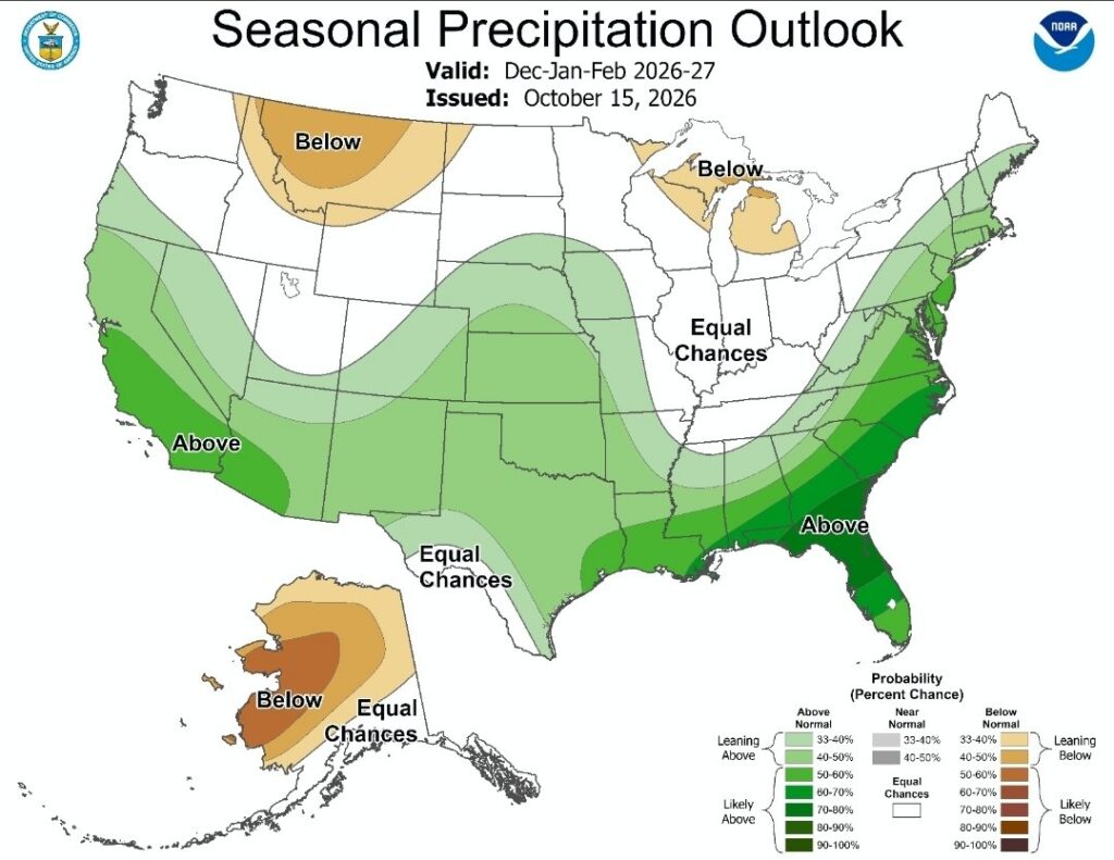
That fits the El Niño pattern of an active southern storm track.
But, a wet winter forecast says nothing about whether shear, instability, or other ingredients will line up on the same night.
At most, it means Florida may get more chances this winter for those ingredients to come together.
In other words, this winter looks a lot like the backdrop of 1998, but whether it produces another night like what happened in late February 1998 will come down to what happens in the days, not months, ahead of a storm.
Preparing for an El Niño Winter in Florida
With the possibility for increased severe weather chances this winter here in Florida, many Floridians are also asking another important question: What can we do to prepare?
While the ingredients that resulted in the 1998 Kissimmee Outbreak can’t be predicted months ahead, the warning signs of anything similar happening this winter will look a lot like what happened in 1998: a deepening low over the Gulf, a warm front or leftover outflow boundary draped across the peninsula, and rich moisture surging up the spine of the state.
Whether you’re visiting our great state, a seasonal resident coming back to escape the cold, or an everyday Floridian like me, the practical takeaways from the 1998 Kissimmee Tornado Outbreak are clear: have reliable ways to get warnings, no matter the time of day, and know where you’ll go when one is issued.
Two sure-fire ways to receive warnings are a NOAA Weather Radio with an alarm and emergency alerts enabled on your phone.
If you’re visiting or don’t live here year-round, be sure to know which county you’re in.
And whether you live or stay in a house, a mobile home, or an RV, have a plan for where you’ll go if a tornado warning is issued for your area.
In a sturdy home, that means an interior room on the lowest floor, away from windows.
In a mobile home or RV, it means knowing ahead of time which sturdier building you can get to.
The best way to approach this El Niño winter isn’t to be scared — it’s to be prepared!
Comments
Join the Conversation